
On Saturday, May 9th, 2015 at 11am all six members of my group summited Mt. Shasta at 14,179ft via the West Face. The altitude sickness most of us experienced over the last few hundred feet made it an incredible mental hurtle. All of us had a base of hiking, backpacking and rock climbing experience, but this was our first mountaineering trip. Below you can find our planning materials and trip report to assist you on your climb.
Summit Trail Summary
- Bunny Flat (6959 ft) to Hidden Valley (9400 ft): 3 hr up / 2 hr down
- Hidden Valley to West Face Rim (13000 ft): 7 hr up / 2 hr down
- West Face Rim to Summit (14179 ft): 2 hr up / 1 hr down
Research
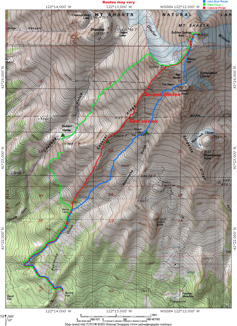
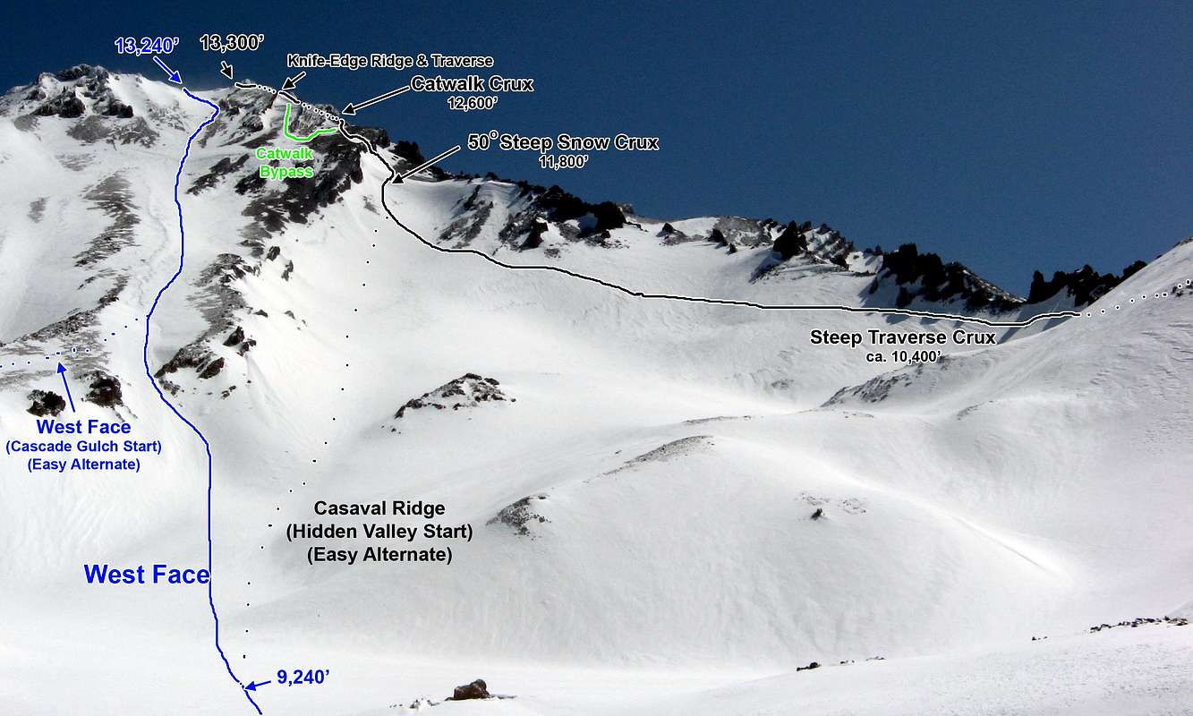
The best resource by far to learn about the climb was attending a “Climbing Mt. Shasta” talk hosted by my local REI in the South Bay Area. Speakers have included the head ranger for the Mt. Shasta Ranger District and a guide with 100+ ascents. For online Shasta climbing information I found Mount Shasta Avalanche Center’s Avalanche and Climbing Advisories to be great along with a Climber.org blog post and Summit Post. For maps I found ASI had the best side-by-side routes followed by Shasta Avalanche Center and this image from summit post. I also used AllTrails Pro’s maps.
Training

For training I hiked 3x a month often with 10+ miles and 3000+ ft elevation gain. For each of these hikes I wore a 40 lb pack. This being my first mountaineering ascent, I learned a lot from an Introduction to Snow Climbing training course on ice axe / crampon usage and self arrest. The same weekend as the class I went on an overnight backpacking trip to test out all my gear on snow. After Shasta, a number of us thought high-energy endurance training such as trail running would have helped our bodies use oxygen more effectively and would have improved our performance at altitude.
Weather

Winds on Shasta can easily reach speeds that can blow you off the mountain and those winds can bring in clouds quickly reducing visibility to white out. To check weather before we went we called the Shasta Avalanche Center, repeatedly talked to The Fifth Season in Shasta City and checked a Mt. Shasta webcam. Even off hours, The Fifth Season is great to call since they have a voicemail they update daily with climbing conditions.
Leaving the Bay Area

We picked up our mountaineering gear from the Outback Adventures Fremont office around noon and left the South Bay at 6pm. Remember to make a rental reservation in advance since all other boot rentals in our sizes were booked our weekend. After one dinner stop we arrived at a snowless Bunny Flat with a decently filled parking lot around 1am. The following permits, last minute adjustments, a 1/4 mile hike and making camp took a little bit and our heads finally hit the pillow around 3am.
Hiking to High Camp

We gave ourselves a minimum of four hours sleep and woke up at 7am so we could hike on the early morning firm snow. It took one hour and 40 minutes to eat and pack up camp. It only took an hour hike on patchy snow to reach Horse Camp at 10am. It hosted a running spring (no filtering required) and a toilet. The trail from Horse Camp towards Hidden Valley was a little unclear until we crossed over Casavel Ridge and saw tracks in the snow . The ridges were full of loose rock, but snow fields filled in between them. The snow was warm by this point so we didn’t use ice axe or crampon to reach Hidden Valley around 1pm.

Starting from this last ascent to Hidden Valley there was continuous snow all the way to the top. We set up camp near a rock to help with wind and had lots of wet, warm snow to build snow walls for our tents. (There had been warnings of high wind)

Weather in Hidden Valley ranged tremendously. It became so hot from the sun out that a couple of guys took off their shirts. However, if a cloud blocked the sun it could drop from 70 degrees to 30 in an instant. Our next task was collecting lots of undisturbed snow to melt for hyper-hydrating. We didn’t boil it since surface snow should be relatively uncontaminated. After a few hours of setting up camp, practicing glissading / self arrest, and shooting the shit we attempted to sleep at 6pm.
Ascending the West Face

We woke at 2am the next morning for our alpine start and left camp at 2:40am. We all wore headlamps, but we didn’t need them since the moon illuminated the snow, reflecting off our metal crampons. It was quiet, windy and cold as we headed towards the mountain.

While climbing, the group stopped every 1000 ft for a 5-10 minute food and water break. We soon realized what looked “not too bad” from Hidden Valley was a tiresome slog up the West Face. We started feeling cold under the mountain’s shadow around 12,000 ft, but it was manageable if we kept moving.

Reaching the top of the West Face at 13,000 ft around 9 am we welcomed the sun, but the winds reached over 40 mph in the open. When we traversed the ridge above the Whitney Glacier wind gusts could push us around.

Climbing started to become incredibly difficult starting at Misery Hill. My breaths doubled in length for half the output. Upon reaching the top of Misery Hill four out of the six mountaineers had altitude sickness with bad headaches, dizziness, poor motor control and fatigue. I was stumbling forward with a headache and had a hard time holding onto my ice axe. My pace reduced to a slow walk and I became overly emotional, almost producing tears when some guy fist bumped me. With the summit in sight it was mainly a mental challenge over the body.

We summited at 14,179 ft at 11am and signed the register. Our descent consisted of walking until about 12,000 ft when the snow became soft enough to glissade.
The instant I started glissading my headache started to feel better. In 45 minutes I had reached Hidden Valley and gone down 2,500 ft. A quick note, everyone’s pants (hiking, rain, snow) were ripped up by glissading except the guy wearing mountaineering pants or someone wearing board shorts over them (for the sole reason of protecting their pants).

We reached camp at 2pm, ate and rehydrated. We chose to hike out the next day because we didn’t want to hike with packs on slush out to Bunny Flat and no one wanted to drive home that night.
Leaving the Hidden Valley

We woke a little after sunrise and left Hidden Valley around 7:30am. We used ice axe and crampon for the first traverse because it was quite icy and had more fall risk. However, we put the crampons away (keeping the axe) the rest of the trek to Horse Camp. After filling from the spring at Horse Camp we reached Bunny Flat at 9:30am. Our faces red and rough from sun and wind burn despite keeping our faces covered the majority of the time on ascent.


